
ASEA is the operator of the subject Campolattaro dam on the river Tammaro. (dPR,,it,and L,,it 1363/59 e L. 584/94 e ss.mm.ii.)
Management activities are divided: in the completion and operation of the dam; in implementing the utilization patterns of potted water; nel presidio e nei vari ambiti di monitoraggio tecnico ambientale dell’invaso.* Tale attività è dettagliatamente disciplinata dal FCEM – Foglio Condizioni per l’Esercizio e la Manutenzione, la cui ultima versione redatta ed aggiornata dall’ASEA è stata sottoscritta con la Direzione Generale per le Dighe del MIT in data 20 April 2018.
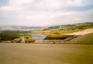
The dam is currently in experimental exercise,it,It was finally possible to start the final phase of the test,it,The maximum processing share of the reservoir,it,It was reached for the first time in November,it,during,it,Functional testing should be obtained e,it,consequentially,it,conclude the phase of experimental reservoirs and start the ordinary one,it,With funds referred to in the CIPE resolutions,it,The following interventions have been carried out or are being completed,it,the installation of hydrometric stations,it,the increase in the piezometric instrumentation,it,The seismic revaluation of the dam and all accessory works,it, il riempimento avviene per gradi seguendo la procedura precisi protocolli tecnici. Con la conclusione dei lavori per la realizzazione della variante alla strada “Senzamici” ricadente nel comune di Morcone, settembre 2018, è stato possibile finalmente avviare la fase conclusiva del collaudo. La quota di massima regolazione dell’invaso: 377,25 m.s.l.m. è stata raggiunta per la prima volta nel mese di novembre 2022, nel corso del 2023 dovrebbe essere conseguito il collaudo funzionale e, di conseguenza, concludere la fase degli invasi sperimentali ed avviare quella ordinaria.
Con fondi di cui alle Delibere Cipe 54/2016 e 12/2018, sono stati realizzati o sono in fase di ultimazione i seguenti interventi: l’installazione delle stazioni idrometriche, l’incremento della strumentazione piezometrica, la rivalutazione sismica della diga e di tutte le opere accessorie, The restoration of the crossbar of Tammarecchia and the construction of a mini-hydroelectric system with a power of about 400kw with use of the flow rate corresponding to the minimum vital outflow to be returned to the Alveo del Tammaro downstream of the dam,it,The Board of Directors of the Cassa per Mezzogiorno gave the definitive green light to the work for an initial total cost of,it,The dam project was drawn up by the engineer Pietro Vecellio,it,• Fee of maximum adjustment,it,Authorized invasion share,it,maximum adjustment,it.
L’ASEA, then, intende valorizzare la realtà complessiva dell’invaso di Campolattaro, come volano di sviluppo sostenibile del territorio, materializing potable use, irriguo ed energetico delle acque. Non secondaria l’azione di tutela e valorizzazione naturalistico-ambientale e di promozione turistica del contesto della diga.
*The service of management and technical environmental monitoring of the reservoir consists of,,it,• Monthly Survey of top and survey data,,it,• bi-weekly measurements of piezometric levels and inclinometer,,it,• Measurements of the biweekly settle meters of joints,,it:
- Guardiania – surveillance
- Ricognizione periodica della struttura
- Rilievo giornaliero dei livelli d’invaso
- Misurazione giornaliera portata idrica dei dreni
- Rilievo giornaliero dei dati metereologici
- Rilievo mensile dei dati alto e planimetrici
- Misure bisettimanali dei livelli piezometrici
- Misure bisettimanali dei giunti
- Misure trimestrali degli assestimetri dei giunti
- Misure trimestrali degli inclinometri
- Manovra degli organi di scarico
- Manutenzione della struttura: cleaning flounces, access roads, the channel paths and gutters
Technical report and analysis on flood events,it 14-19 October 2015
Rivalutazione della sicurezza idraulica ed idrologica della diga, settembre 2017: Studio – Allegato I – Allegato II


On 11 December 1980, by resolution No.. 3701, il Consiglio di Amministrazione della Cassa per il Mezzogiorno diede il via libera definitivo all’opera per un costo complessivo iniziaale di 69 billion and 344 million lire. Il progetto della diga fu redatto dall’ingegnere Pietro Vecellio.
• Quota di massima regolazione: 377,25 meters above sea level
• Maximum Quota overrun: 381,45 meters above sea level
• crowning Plan: 387,40 meters above sea level
• Width of the crown: 9 meters
• Development of crowning: 820,60 meters
• Maximum height of the embankment: 62,90 meters;
The annual maximum accumulation of water is expected to be approximately 109.000.000 m³, as follows: 89.000.000 m³ from Tammaro (which implies a catchment area of about 256 Sq km., amounted to just over 10% of the Province of Benevento area); 20.000.000 m³ arising from the eaves beam on "Tammarecchia" (which implies a basin 75 Sq km.). The volumes of water used each year are considered equal to 87.200.000 m³.
Work began in 1981 and they were completed in 1993.
The Campania Region, with the Council resolution No.. 1178 of the 7.3.1995, spotted the managing entity in the Province of Benevento, with the understanding that the same it would use the authority's cooperation for the Irrigation Development and Land Transformation in Puglia, Lucania and Irpinia. On the basis of that decision, pursuant to Legislative Decree No. 96 of the 1993, the Acting Commissioner appointed by the Ministry of Public Works moved, by decree n. 6473 of the 29.1.1997, the Province of Benevento the project work completion.
Thanks to the efforts of the then Government of the Province of Benevento, il 29 April 2006, It was started work testing the closure of the gates and, therefore, with the beginning of the formation of the artificial lake. The filling of the reservoir, It takes place by degrees, obeying the procedure on precise technical protocols.
from 1 January 2014 ASEA is the subject of the dam manager, placing the precise purpose of testing the work and activate the uses, drinking, water and energy.
Statistics
The reservoir of Campolattaro falls in an area of many habitats and species of fauna and avifauna; this ecosystem is recognition by the European Commission as they have been identified as part of the Nature Network 2000 l’Area Sic (Site of Community Interest) “Alta Valle del Tammaro River"And Zps Area (Special Protection Area) “invaded Tammaro“. Within them is protected natural area of about 1.000 hectares WWF Sannio with which the ASEA has signed an agreement for the management. For the public: the Oasis visits are made on Sunday from hours 9:00 all 13:30 and every day on reservation
Insights: